
In the June 2019 issue of WCO News, the WCO Secretariat encouraged Customs administrations to examine the use of geodata for more effective border management. Following Niger, it is now Nigeria’s turn to share its experience in the use of geospatial intelligence (GEOINT) – a fusion of satellite imagery, geographic information systems (GIS), remote sensing, positioning data and analytics.
Why geospatial intelligence, and why now?
The borderlands connecting countries across the African continent are diverse in terms of the natural landscape. Vast stretches of desert, forest, rivers and lakes present significant challenges for Customs administrations trying to monitor cross-border activities.
Common pain points include:
In this context, the use of geospatial intelligence (GEOINT) holds significant promise. A new paradigm of knowledge – almost a discipline in itself – GEOINT combines satellite imagery, geographic information systems (GIS), remote sensing, positioning data and analytics to provide a visual representation of geographic features, activities and changes over time.
GEOINT addresses persistent border-management problems, especially in conflict-prone and hard-to-reach areas, by allowing Customs authorities to see, measure and predict events in space and time:
GEOINT does not replace human expertise or inter-agency cooperation – it augments them, providing a single geospatial framework where agencies can overlay data, coordinate responses and target resources more effectively.
The timing for the adoption of GEOINT by Customs is favourable. High-resolution commercial satellite constellations have driven down costs; mobile coverage and GNSS-enabled devices are now widespread; and cloud-based geospatial platforms have lowered barriers to entry.
GEOINT capabilities relevant to Customs
A modern GEOINT stack for Customs integrates sensors, platforms, analytics and operational playbooks.
Data include:
Data architecture and systems interoperability
A robust GEOINT programme relies on a federated architecture, where data remains with its owner but is accessible and usable via standardized protocols. For example, Customs manages data on trade and seizures, immigration authorities manage border crossing data, maritime and aviation authorities track vessel and aircraft movements, and environmental agencies manage natural resource data. Most standards relevant to geospatial data are developed by the Open Geospatial Consortium (OGC).
In Nigeria, investments have focused on secure servers, geospatial databases and connectivity, while internal competencies in GIS, remote sensing, data science and system administration have been developed through training and targeted hiring.
Core components of Nigeria’s architecture include:
Analytics and applications
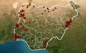
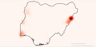
Analytical tools have been developed to detect topographic changes (such as new tracks, river fords, landing strips or warehousing near borders), map hotspots (including the location of seizures, together with their weight and the detection method used, such as tip-offs or intelligence reports) and assess risk on transit routes (based on the terrain, incident history and time-of-day patterns) with a view to instigating targeted inspections.
Most models were developed internally by the Customs GIS and data teams. For more advanced work – such as machine-learning or radar image analysis – specialist external providers were engaged.
Telematics is heavily used to flag anomalies, such as unusual convoy behaviour, AIS signal gaps or suspected transshipments near free ports. The software uses data generated by telematics devices to trigger an alert when a vehicle crosses geofenced boundaries along priority border segments or deviates towards unofficial routes.
Predictive models use historical seizure and conflict data to anticipate smuggling surges. Geo-linked inspections and revenue data then enable Customs to assess the impact of interventions, such as deploying scanners or increasing patrols in targeted areas.
Incident command
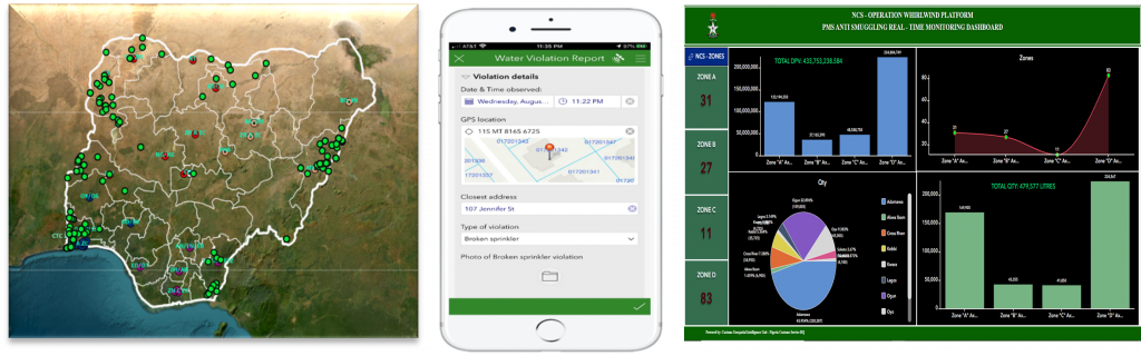
An incident command centre maps incidents, personnel and assets in real time. It also develops common operating pictures (COPs) by integrating information from multiple sources, which are then shared with relevant agencies to ensure coordinated responses.
The NCS incident command is run by Customs officers with backgrounds in GIS, operations and IT. They integrate real-time feeds into COPs, adapt analytical tools based on field feedback and update models according to operational outcomes.
Community engagement
Communities are involved through awareness campaigns, cooperation with local leaders and reporting mechanisms such as hotlines, mobile apps and in-person briefings. Although monetary incentives are not standard, recognition and feedback are used to encourage participation.

Use cases
Detecting illicit crossings
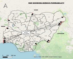
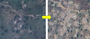
The use of GEOINT has shed light on several illicit activities. For example, at one border crossing, satellite imagery identified newly cleared footpaths leading to an unofficial crossing point. When this was overlaid with seizure data, repeated movements of goods along the route were confirmed. A joint patrol was then deployed, resulting in the interception of vehicles carrying undeclared goods.
Controlling transit corridors and dry port operations
GEOINT-powered corridor dashboards integrate multiple layers of information to reduce variability in transit times and prevent the diversion of goods in transit. This information includes the spatial distribution of Customs checkpoints, the locations of infrastructure such as container terminals, GPS/telematics data on bonded trucks, and broadband and fibre-optic coverage maps, which serve as proxies for connectivity and potential monitoring blind spots along corridors.
Monitoring coastal and inland waterways
Small craft sometimes disable their AIS or hug the coastline at night to avoid detection. Synthetic aperture radar (SAR) satellites, which can detect metal hulls in darkness, are used to track such movements, while drones are deployed to cover nearshore gaps. These feeds are linked to interdiction teams and Customs boats to enable a timely response.
Ensuring operational continuity in fragile settings
In conflict-affected regions, Customs often runs “minimum viable” operations. GEOINT can be used to guide safe routing for officials, track the movement of humanitarian goods, identify market re-openings and map temporary crossings used by displaced populations. It can also provide information to help Customs decide where to prioritize the reopening of Customs posts or deploy mobile units, as well as identify areas requiring coordinated action with other agencies or collaboration with local communities.
Disrupting eco-crimes and protecting natural resources
Illicit activities such as poaching, mining and logging often leave spatial signatures. Open-source intelligence (OSINT) tools can be used to identify mining pits, logging roads and smuggling supply lines. Customs can then partner with environmental agencies to coordinate inspections and conduct community outreach where needed.
Protecting revenue more efficiently
Spatial analytics can enhance valuation and audit targeting. For example, by comparing night-time light data with business registries, Customs can verify whether declared manufacturers are actually operating at the stated addresses. Some traders may use false or shell addresses to evade inspections or taxes, while geo-tagged post-clearance audit (PCA) results can help identify clusters of under-valuation near specific logistics parks.
Governance, law, and ethics
Implementing GEOINT requires a strong legal foundation. Customs administrations must ensure that laws explicitly permit the use of aerial and satellite data for risk management and enforcement purposes. These laws should specify which data can be collected and which data should be anonymized. Moreover, the sharing of data with national agencies – such as immigration, police, defence, coast guard, environmental and statistical agencies – should be formalized through agreements or memorandums of understanding (MoUs).
Some regional agreements, such as those governing regional economic communities (RECs), may also contain provisions on data exchange with other administrations. In Nigeria, information is increasingly shared with regional counterparts through the ECOWAS framework, particularly in joint border operations and anti-smuggling patrols. This has led to coordinated seizures along transit corridors and improved early warnings about diversion risks, although the practice is still evolving and requires stronger institutional mechanisms.
The use of OSINT in conflict zones has been a critical concern for the Administration. Geodata is useful for the planning of operations near humanitarian camps or the delivery of aid. However, before sharing any data related to these areas, the Administration applies the “do no harm” principle, assessing the potential impact on civilians. It also ensures that analytical models are non-discriminatory and free from political bias, especially where community dynamics are sensitive.
Financing options and phased roadmap
The initial development of GEOINT capacities within the NCS was funded by the service itself and by donors who supported pilot projects focusing on the use of open-source satellite imagery for border monitoring. Early operational successes in detecting illicit trade activities created momentum for increased investment in this field, enabling the NCS to progress from pilot projects to system-wide transformation.
Today, African Customs administrations are at a strategic crossroads. A recommended roadmap would be to begin with small-scale pilots using open data and GIS, achieve quick wins, secure funding and inter-agency agreements, and then scale up gradually as the system proves effective.
More information
Contact the author