Geodata in use today
State agencies use geographic tools for many purposes: to analyse land use; to plan traffic infrastructure; to monitor the environment and agriculture; to respond to disaster management; and to manage humanitarian aid or to assess development policies. Additionally, some regional initiatives have begun to feature geodata; for example, the European Commission’s Infrastructure for Spatial Information in the European Community (INSPIRE) project, infrastructure built for the purposes of spatial information sharing between public authorities.
The INSPIRE project includes common standards applicable to 34 spatial data themes including transport networks, water networks, and population distribution. The information is available on an online portal, and the data is standardized and can be combined and integrated. However, no economic data related to trade, taxation or security is being collected at this stage.
Law enforcement agencies have also been using geodata for some time; two trends can be observed in this regard. On the one hand, spatial data is being mobilized for “patrimonial” purposes, often culminating in a database or an “image inventory” of that which exists in a country (archaeological sites, animal habitats or forests, for instance), and can subsequently contribute to the detection of crimes and the destruction of patrimonial property. On the other hand, spatial data can be used to better enforce laws within a territory – crime mapping, for example – to enhance understanding of the environmental factors underlying crimes and inform decision-making processes.
New applications of geodata have been identified recently by law enforcement and intelligence agencies with the rise in terrorism around the world: GIS are being used to manage responses to terrorist attacks in urban areas involving hazardous materials (the “geoevent” concept), to evaluate the likelihood of villages being involved in counterinsurgency, and to identify national trends related to incidents of terrorism, as well as critical infrastructure.
Border management
The use of geographical tools by border agencies is relatively low, but it is increasing. In Belgium and the Netherlands, national police services have made some attempts at using geodata for transborder exercises. Some international organizations specializing in border management work are using geodata too, such as:
Within the European Union (EU), the EU Satellite Centre and Frontex, the EU agency tasked with border control covering the European Schengen Area, are using geodata to counter illicit trafficking and smuggling, and will continue to do so as this is the only way to develop a holistic representation of the border through real-time mapping.
Indeed, the use of geodata tools to control the movement of people is a trend that has been observed across the EU, which has been investing in the implementation of GIS for border guard units in countries situated along its external borders. Another trend is the merging of objectives: systems are used to fight illegal migration, as well as terrorism, drug trafficking and smuggling.
But how does Customs position itself in such a context? Customs administrations traditionally use geodata for transit purposes: GPS or RFID devices are installed on means of transport or on containers, enabling officers to monitor, in real-time, the location of goods in transit and to be informed of any incident, stop or deviation from the assigned itinerary. However, in this case, little analytical use is made of the geodata collected.
Apart from cargo tracking, the potential uses of geodata seem to be generally overlooked. A possible reason could be related to the fact that Customs envision their tasks to be primarily concerned with managing flows between major points of entry such as ports or airports. This way of thinking translates into an economic vision of the role of Customs that focuses on the major flows generated by globalization.
Encouraging the use of geodata in Customs will garner meaningful, tangible results both in OECD countries, to understand the future of Customs in a border protection context, and in emerging and developing countries, to develop geodata-based analysis at land and sea borders, where smuggling through land borders is significant and the usual Customs approach developed in a port or airport context is no longer valid.
Potential uses of geodata by Customs
What are the various ways Customs administrations could use to leverage geodata, and what would be the potential benefits?
Different uses of geodata by Customs have already been identified:
Other uses are more exploratory, but have been discussed with WCO Members, such as:
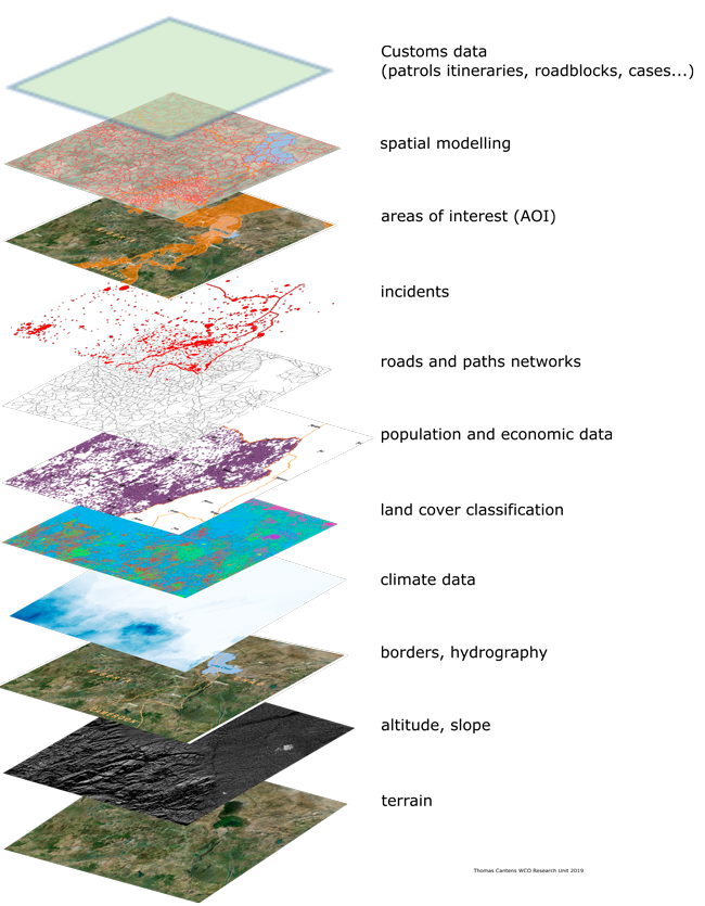
Three technologies can be mobilized:
These technologies can be used together or independently, depending on an administration’s needs and levels of expectation. Stand-alone GIS software can be used by intelligence units to visualize data and share analyses for operational purposes (GIS software integrates major statistics software). A spatial data infrastructure, combining the three technologies, can be imagined for an operation centre collecting information and producing intelligence.
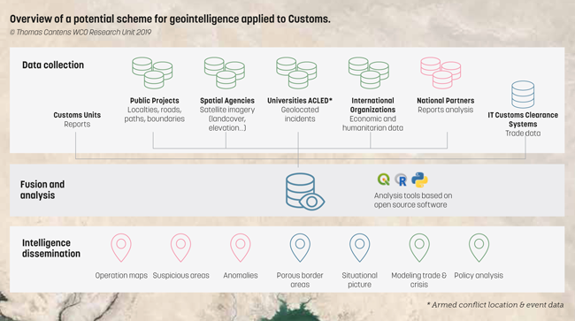
From a border management perspective, these technologies present several advantages in terms of implementation:
What type of data can be sent to spatial data infrastructure, and with what results?
Stakeholders such as border communities, traders and transporters could also communicate geodata on:
The first value-add of the adoption of geodata solutions is that they fit with the professional culture of frontline Customs officers and would encourage them to share their knowledge with their headquarters. Officers have a professional culture based on territory control, particularly in remote areas where field knowledge is highly valuable for daily Customs operations.
Moreover, Customs officers already have a strong culture of measurement and statistics, but the two kinds of thinking – geographical and statistical – are utilized by different actors within administrations: whilst statistics are usually handled by central units or units positioned at headquarters, the field knowledge possessed by frontline officers is rarely “organized” to such an extent that it becomes transferable for analytical purposes.
In a best case scenario, the field knowledge that is structured to circulate within an administration relates to smugglers’ modus operandi: fraud cases are taken up by central intelligence units, which structure the data and disseminate it among all field services. But the field officers’ knowledge covers more than fraud cases; it ranges from the nature of economic operators, to the evaluation of wealth circulation, to the most common kinds of flows, and the usual routes.
This kind of knowledge intuitively establishes linkages between different kinds of factors, whether environmental, economic, geographic or cultural. All this data that is intuitively collected by Customs officers in the field is not directly related to fraud cases, but it helps the officers to detect abnormal behaviours and fraud.
Geodata applications make data available in the form of maps, sometimes in real time. The visual dimension is important as it enables internal dialogue between Customs specialists with different backgrounds and cultures (analysts, statisticians, field officers and managers), and helps leaders to take decisions in real time including optimizing the presence of units in the field.
In addition, geodata solutions that mobilize regular or real-time mapping of, for instance, commodity flows, fraud, incidents, patrols and trucks, would create linkages between different kinds of knowledge in a Customs administration. Moreover, mapping data offers a great opportunity in terms of cooperation, as it facilitates dialogue with other border agencies or public actors like the police and the army, experts from different backgrounds and even different countries.
Regional integration
Another area where geodata-based solutions can have a crucial impact is regional integration. In many developing countries, regional integration is promoted via transit corridors whose strength lies in the possibilities they offer for confronting the concerns and interests of all stakeholders and in developing different schemes of cooperation between Customs (from the settlement of foreign Customs offices in a port to joint border posts or roadblocks). However, these transit corridors are, above all, a means to secure transit from a revenue perspective.
Regional exchanges are not limited to these corridors; they also exist between border communities and alongside long, historical trade routes, which are not well equipped, but enable traders to convey high volumes of commodities. Such routes play a crucial role by linking remote areas with these very corridors as well as with trade-hub cities.
The lack of knowledge and governance capacity regarding these routes may generate losses of revenue and the rise of informal governance by non-State actors, which could create conditions for economic inequalities, dissatisfaction with the State, insurgencies, and even violence. Therefore, it is crucial for Customs to monitor these routes and borderlands to facilitate legal trade, ensure trade compliance, and mitigate security risks from a regional perspective.
Conclusion
By generating geodata with applications to their fields of interest (borders, trade, transport, logistics, taxation, corruption, etc.), Customs administrations will be able to strengthen their role in border management, as an intelligence, security, policy and development actor.
Further leveraging of geodata would not represent a revolution within Customs. Indeed, this geodata relies on what already exists, augmented by a geographical dimension: instead of sharing data that is manually registered by a focal point in a national, regional or international database (like the WCO’s nCEN or CEN), a spatial data infrastructure could make use of both GIS and mobile phone capacities to automate the collection, dissemination and representation of data as it relates to Customs and trade activities.
As the use of geodata is increasing, it is time for Customs administrations to renew their attention to the tools available out there, which could be of great use to them in the collection and exploration of data, with a view to both securing and facilitating cross-border economic activities.
More information
research@wcoomd.org
[1] See, for instance, QGIS at www.qgis.org