The WCO and the European Union (EU) are partners in a new project called “COLIBRI,” which aims to build the capacity of Customs administrations to control general aviation on routes between Latin America, the Caribbean and Africa, as well as between the EU and these regions.
What we know as general aviation comprises all civil aviation activities other than commercial transport: sport or leisure aviation, private aviation, business aviation and aerial work (search and rescue, aerial spraying, mapping, surveillance, etc.). General aviation is permitted to use government-owned, private and most civil airports (access to some civil aerodromes is restricted to commercial flights only).
To enable administrative authorities to exercise control over international movements of general aviation aircraft, national legislatures generally require certain documents to be provided, such as the flight plan, documents on the status of the aircraft, documents on the goods being transported, and documents relating to the persons aboard and their luggage.
However, general aviation is not subject to the same Customs or police inspection mechanisms as commercial aviation. Flight security measures are considerably less stringent, even in areas that are as well-regulated as European countries, which hampers the ability to track flights.
What is more, light aircrafts often need only rudimentary infrastructure to take off and land. All that is required to allow the most experienced pilots to take off or land is a stretch of flat ground a few hundred metres long and a few dozen metres wide.
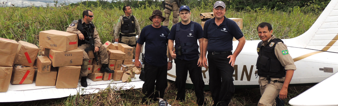
This means that general aviation represents a genuine opportunity for organized crime, offering a number of advantages to traffickers. This is a discreet, fast mode of transport that can use smaller airports, where law enforcement agencies are often absent.
Responses to the risks associated with this mode of transport vary. Some countries have military surveillance capabilities and have accordingly established proper airspace control, employing radar coverage to identify clandestine flights (where the transponder is switched off) or suspect flights (on the basis of discrepancies between the flight plans filed and the radar data analysis of the flight plan’s historical data), and carry out air interception operations.
Meanwhile, monitoring of aerodromes, although difficult to carry out in practice, is essential. This involves a risk assessment, to be conducted on the basis of route mapping, taking account of a number of criteria, such as the accessibility and protection of the platforms. A first stage in implementing a more effective control policy is a census of aerodromes and the aircraft based there.
Moreover, working with international flights involves intensified operational cooperation with the authorities in neighbouring countries and on other continents.
The project aims to support Customs administrations in Latin America, the Caribbean and Africa in the implementation of effective controls. Focusing specifically on general aviation, COLIBRI is a further project carried out under the EU’s Cocaine Route Programme, which, in particular, features the AIRCOP Project, implemented by the WCO, the UNODC and INTERPOL, primarily aimed at stepping up inter-agency cooperation at international airports.
The main activities of the project will be to:
- evaluate the needs of the countries concerned as a start, identifying the teams and training them in intelligence handling and techniques for targeting and inspecting aircraft in transit at international airports, as well as small aerodromes, and even clandestine airstrips;
- create a real-time operational communication system, facilitating the sharing of information at national and international level;
- develop a spatial database recording information about, and controls carried out on, aircraft, and a mapping tool offering the possibility of exploiting geographical data to identify and analyse risks;
- carry out regular inspections and control operations in the various regions involved in the project to evaluate and strengthen the mechanisms used.
More information
enforcement@wcoomd.org