

Participants in the MTP on GEOINT learn how to:
The GEOINT Master Trainers reported that they applied their newly acquired skills shortly after completing the programme. Some contributed to the establishment of dedicated GEOINT units or are in the process of doing so. Others have already used geospatial analysis to inform enforcement actions. The geospatial dashboards they developed supported faster and more informed decision‑making by providing a shared operational picture. They also highlighted the value of GEOINT in strengthening internal coordination. The visualization of operational data through digital maps facilitated clearer communication between headquarters and field units, particularly during the planning of joint operations.
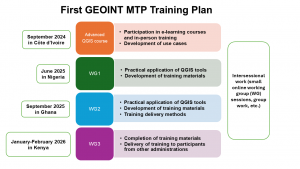
In February 2026, a second cycle of the programme was launched, bringing together 28 officers from Burkina Faso, Cameroon, Egypt, Ethiopia, Guinea, Kenya, Liberia, Mali, Mauritania, Niger, Senegal, Sierra Leone, Tanzania and Uganda. By June 2027, they should have completed their training and begun working on the use of GEOINT in their respective administrations.
At the first training session of this second cycle, the GEOINT Master Trainers supervised hands‑on exercises on the use of QGIS and taught participants how to use GEOINT. This peer‑to‑peer training model is essential for ensuring the sustainability of the WCO GEOINT training programme. It also enables reciprocal learning, whereby trainers and trainees learn from each other’s experiences and real-world insights.
More information
Contact the Master Trainer Programme
[1] Managed by the WCO in close partnership with the Japan International Cooperation Agency (JICA), the MTP aims at building sustainable and autonomous training capacity in Customs administrations in key Customs areas. See WCO News 106 – Issue 1/2025: https://mag.wcoomd.org/magazine/wco-news-106-issue-1-2025/wco-jica-master-training-programme.